
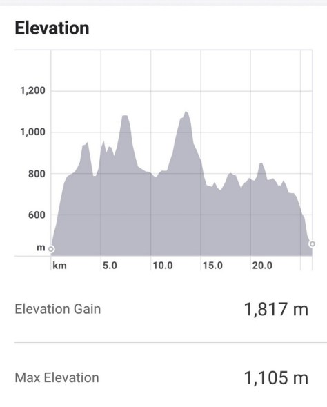
Or as I prefer, the West-East Vertical Traverse! This is THE mountain challenge for all those looking for a day out from Taipei, an 11-hour hike over the 10 mountains in the Yang-Ming Shan range that lie just above Taipei City. It’s effectively a ridge walk, total 26.25 km (16.3 miles), 1,817 m (5961 ft) of ascent and over 53,000 steps in total. And totally worth it!
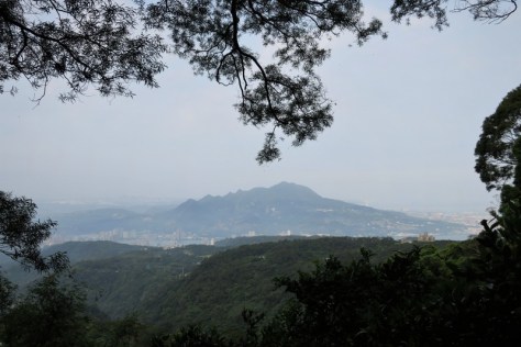
This post is an adapted version of my previous trip published here on October 28, 2019, but updated because I’ve just done it again, yesterday, April 18, 2020, and also because all 10 summits are now open to the public. The photos below are those taken yesterday too (except for this one, added as a further update, taken on May 1, 2020 of the view of the whole ridge, as seen from Taipei City, actually taken on the Shezidao Bridge at 7:00 am, far left is Mt. Xiangtian).

Spring or autumn is the best time to do this hike, because summer is Qixing too hot (and it rains nearly every afternoon) and winter is too wet. You need a number of dry days before the actual day, otherwise the paths are slippery, especially the roped ones. So yesterday fitted the bill exactly!
The first time I did this hike was in May 2018 (see that account here), but by the next time, in October 2019, the route had slightly changed, with one of the summits (Mt. Zhugao 竹篙山 ) closed to the public – to avoid the cattle, which are actually a mix of water buffalo and Tajima cattle, after someone was killed by one. The Mt. Zhugao summit marker post was moved to the highest point on the Lengqing Path, and renamed Jixinlun 雞心崙. Now it’s all open again, though the Jixinlun summit marker is still there – but it is hardly a real summit, so the big challenge lies in including Mt. Zhugao back in the itinerary once again. So that’s what I did yesterday – and just made it on time!
Fortunately the whole hike can be done in more manageable and smaller sections – it divides nicely into 4, which can be done over 4 days or 2. If you take the harder option, and do it all on one day, be prepared for aching limbs for 3 days afterwards – it’s hard work! Check out yesterday’s elevation record….
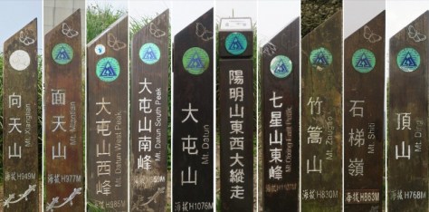
On each of the summits, there is a marker post, and on the top of each post is a Chinese character in metal ~ use a pencil and paper to do like a brass rubbing (or just take a photo!) Put together in order and these characters make a phrase. The 10 Chinese characters are: Mt. Ding (“陽”), Mt. Shiti (“明”), Jixinlun (“山”), Mt. Qixing East Peak (“東”), Mt. Qixing Main Peak (“西”), Mt. Datun Main Peak (“大”), Mt. Datun South Peak (“縱”), Mt. Datun West Peak (“走”), Mt. Miantian (“活”), and Mt. Xiangtian (“動”). The whole phrase, 陽明山東西大縱走活動 translates as the ‘Yang-Ming Shan East-West Vertical Traverse Activity’. These are the 10 summit posts (left to right in the order I did them), though with Mt Zhugao instead of Jixinlun ….
Although it is titled the East-West Traverse, and the marker posts are numbered in that direction, actually it is easier to do it from west-east, mainly because of the times of the buses. The east end of the hike is a place called Fengguikou 風櫃口. The bus stop is about 1 km down the road from there, at a place called Fengguizui 風櫃嘴. The bus is the small city bus M1 (市民小巴1) from Jiantan MRT Station, and there’s not many of them! Every morning, the first bus leaves Jiantan MRT Station at 6:10 am going up to Fengguizui, taking about 30 minutes. The next bus after that is 10:10 am, so don’t miss it! The Taipei MRT opens at 6:00 am each day, so for those of us further away, it’s impossible to get to Jiantan MRT Station so early.
You also need to know that the final M1 bus of the day from Fengguizui down to Jiantan MRT goes at about 6:10 pm. That is the one to get! If you miss it, you have to walk down much further to Shengren Waterfall Bus Stop where there are many buses, but the road is long and winding, and the short-cut paths are steep – plus by then it’ll be dark, so timing is everything! The other reason for finishing at Fengguikou rather than starting from there is that the final part of the hike may be be long (6 km from Qingtiangang 擎天崗) but it is the least steep part of the whole hike, and after a long day going up and down, it’s nice to take things a bit more easily!
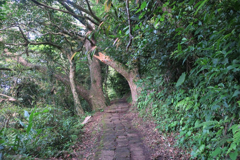
So all in all, I think it’s better to start at the west end of the hike, which is at Qingtian Temple 清天宮登山口 and walk eastwards. The bus you need is the S6 (小6) bus from Beitou MRT, and there are lots of buses all day long, and lots of people on a weekend all queuing for the early buses! Get there early. The earliest I could get to Qingtian Temple on Saturday was at 7:15 am. Qingtian Temple village has a temple or two, a public toilet and a large noticeboard with a map. The whole trail is very well-signposted as long as you know the order of the mountains. The trails on Yang-Ming Shan were mostly built in the Japanese Era, and they were built to last forever, mostly of stone. This is the view from Qingtian Temple Trail-head over towards Guanyinshan…
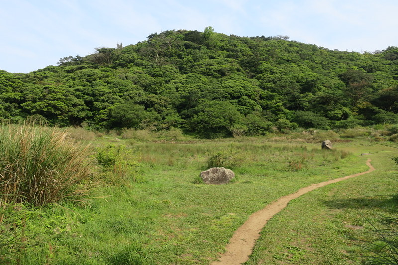
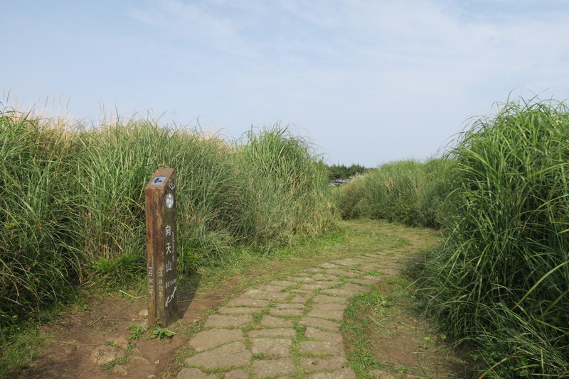
The trail from Qingtian Temple to the first summit of Mt. Xiangtian 向天山 takes just over an hour, going via the usually-water-less Xiangtian Pond. The path is nearly all in the trees, and among the bamboo, so it’s shady – but also slippery in wet weather…


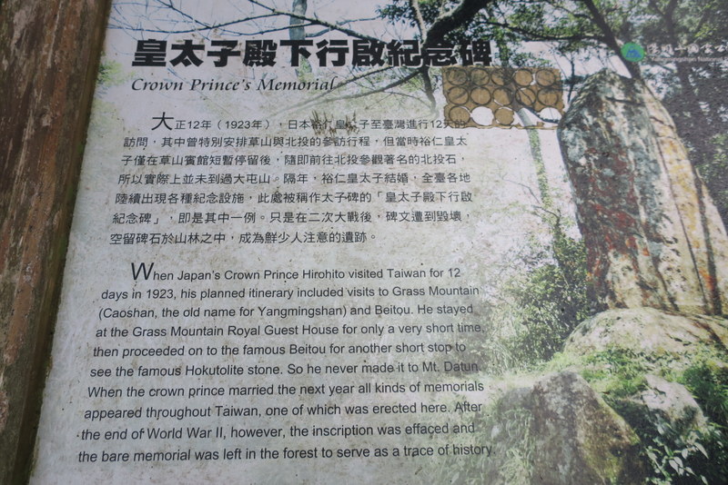
On the way, you pass the Memorial Stone to Japanese Crown Prince Hirohito, erected in honour of his visit to the area in 1923 and his marriage the following year…

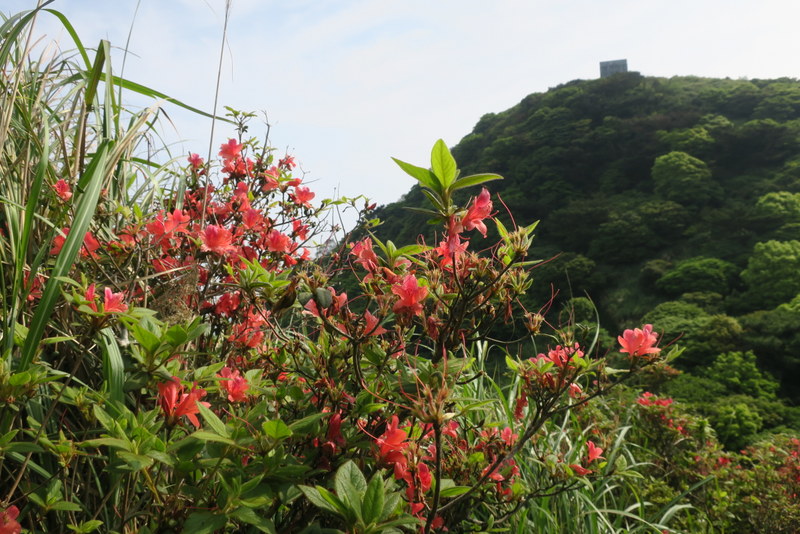
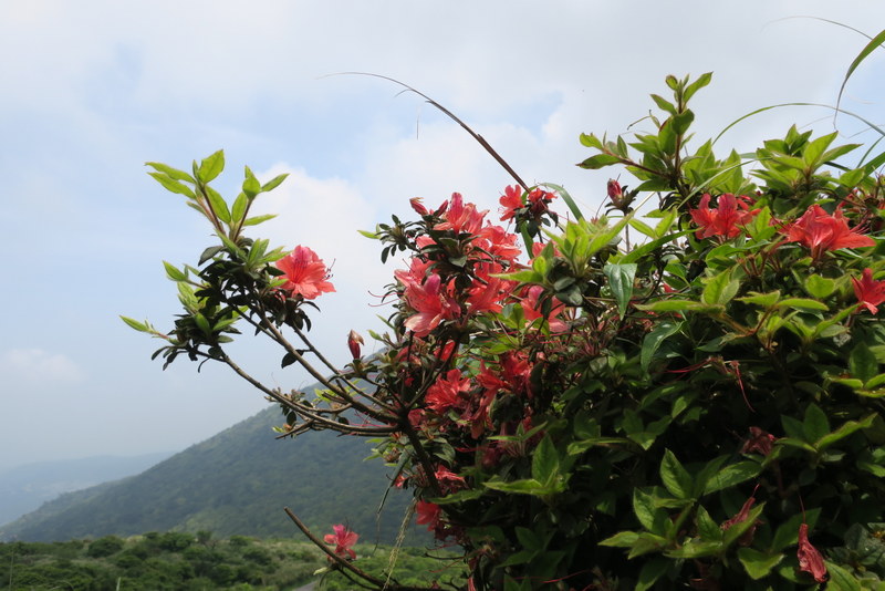
I was on the grassy summit of Mt. Xiangtian (949 m) by about 8:40 am – check out the Oldhams Azalea (Rhododendron oldhamii) – endemic to Taiwan and in flower all over the mountains at this time of year….

Twenty minutes later, I reached Summit 2, Mt. Miantian 面天山 (977 m) at 9:00 am. There’s a viewpoint and raised rest area there, 2 huge microwave reflectors and views down to St. John’s University and the whole northern coast – but it was hazy. No problem, it saved me time not taking so many photos, and time was a bit of the essence!
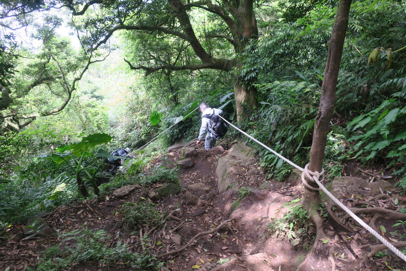
Taking the path straight down from Mt. Miantian leads back to the main path. Turn right for about 10 minutes heading to Miantianping 面天坪, where there’s a pavilion always full of people enjoying a day out. The path up to Mt. Datun West and South Peaks (and eventually to Mt. Datun Main Peak) starts here, on the left. The Datun Mountain range 大屯山 lies ahead. This is the steepest part of the whole hike coming up. Bring some cheap gloves to cling onto the fixed ropes that are provided to help you haul yourself up and down. Yesterday it was very slippery, and without ropes would have been a nightmare. But be prepared for aching arms and shoulders!


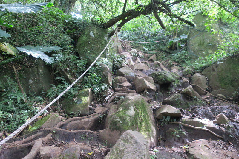
The ascent of Mt. Datun West Peak 大屯西峰 is steep and exhilarating, with lots of large rocks to get over. The top (985 m) is mostly rocks too, and the descent is equally steep, so it’s better to go down backwards. At the bottom, head on to Mt. Datun South Peak 大屯南峰, which is a shorter but even steeper climb than West Peak…
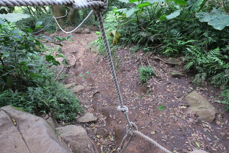
However once you get to the summit (959 m), that’s it with the ropes (and the gloves), they won’t be needed any more on this hike. The descent is much easier. The path brings you out ready to hike up to Mt. Datun Main Peak 大屯主峰, which is a bit of a slog up endless stone steps. The summit (1076 m) is high up above the path, there’s a viewpoint, and it’s the top of the road for the cyclists who like to come up on their bikes from Taipei. On Saturday, it was mostly foggy, so no views, but on a clear day the views of Taipei are great. You can drive up here by car, but not during the butterfly season, which is happening now. By then it was almost 11:30 am. 5 mountains down, 5 to go. We’re half way along – yes!

Then follows a long walk down from Mt. Datun Main Peak, either by road, or by path to the Anbu Entrance. I took the path, it comes out at the road, and there you turn right. Heading to the next big mountain, Mt. Qixing ~ and it is easier (but definitely not so pleasant) to walk along the main road. There are buses, cars and cyclists coming from all directions, but following the trail along down below the road is mossy and often slippery, and takes ages. I walked along the road – to the junction, then cross over and turn left, walk up to the car-park and up over the small grassy hill – spurred on by the call of the coffee shop at Xiaoyoukeng!

At Xiaoyoukeng 小油坑遊客服務站, the fumaroles were spouting forth tons of yellow and white sulphur gases, stinking the place out. They are fun to check out. There’s also a visitor’s center (with maps, displays, water machines to refill water bottles, and friendly National Park people to answer all your questions), toilets and coffee shop. Due to the coronavirus precautions, like all government buildings, there is someone on duty to check temperatures of those coming in to the center to fill up the water bottles – and you need to wear a face-mask. Face-masks are also compulsory on all public transport – never go out without one!


From here, spurred on by coffee, it’s time to launch forth up the highest mountain of the day, Mt. Qixing 七星主峰. The newly-restored path is beautiful. This is always the place with the most people, and the youngest people – groups of students, young couples and families. And yes, it was heaving, but it’s not a difficult climb, in fact it’s fairly manageable even for people more used to walking in high heels on city streets, hence the vast numbers of people going up at the weekends. I got to the top (1120 m) at about 1:30 pm, and there was a line of about 30 people queuing to take photos at the big summit post.

About 20 minutes later, I got to the top of the Mt. Qixing East Peak七星東峰 (1107 m). From there, the descent is long. I got to the Lengshuikeng Visitor’s Center 冷水坑遊客服務站 at about 2:45 pm, time to refill the water bottles and cool down. But time was moving on – gotta get to that bus! But first I had to go to Mt. Zhugao 竹篙山 via Jixinlun 雞心崙, the highest point on the Lengqing Path. You walk eastwards from the visitor’s center on the path, cross the bridge and turn right towards the pond. At the pond, turn left up the steep steps. At the top of the steps, turn right, and about 5 minutes later is a viewpoint, and the marker is positioned there. Then on to Qingtiangang 擎天崗, which was also full of people. Everyone was there to relax on the grass, eat picnics and see the cattle. There were plenty of big fat buffalo, all lazing around, and all very smelly – these ones in the photo are Tajima cattle…


Eight summits down, two to go. At this point many people give up and go home by bus. The next section and challenge is to cover 6 km (plus a further 1 km by path / road to the bus stop) to get to the eastern end of the trail at Fengguikou. But this is also the nicest part in many ways. The trail alternates between forest and grassland, finally getting to the summit of Mt. Shiti / Shitiling 石梯嶺 (863 m). Beautiful! By then I was running very late, and only got to the final summit, Mt. Ding 頂山 (768 m) at 5:20 pm, so it was non-stop action from there, on down to Fengguikou Trail Head 風櫃口登山口. At the car-park, there’s a path immediately to the right that goes from the trail head to cut off the winding road.
I arrived at the Fengguizui Bus Stop just as the bus appeared – it goes up to the terminus, turns round and comes back and picks up all the people at about 6:15 pm. Five minutes later and I would have missed it, and would have faced a long walk down that steep hill to the Shengren Waterfall bus-stop. Phew, was I relieved!
This is a highly-recommended but a bit-of-a-killer hike and I am expecting to be aching for the next week! Very grateful for cool-ish weather, not much sun, hardly any real mud, ropes, dry paths, friendly people, hot coffee, easy access, good and cheap public transport, friendly and knowledgeable National Park staff, clear signposts, spring flowers, energy, free time and strength – and especially in this time of the coronavirus when so many other people in the world are in lockdown, grateful that here we are, free to do a whole day of hiking in the mountains. Thanks be to God!
PS The 2021 version of this hike, done on February 21, 2021 had much sunnier weather, and so much better photos. Check them out here

An amazing walk through wonderful scenery. Congratulations on having done this three times now!
Thank you, and hope all is well with you!
Absolutely amazing. It’s so beautiful which makes the trek so worthwhile…well done Catherine.
Thank you!
Well done Catherine! Always providing us with lovely photos of Taiwan’s beautiful landscape! It’s a joy!
Blessings
A
Thank you!
Well done, Catherine. Amazing, as you say, that you can still do a hike like that when the rest of us are in lockdown. I enjoyed walking with you, virtually, from the comfort of my couch. Love, Sarah
Thank you!